A series on West Kootenay/Boundary place names
Look at Rossland on Google Maps and you’ll go away thinking the city has no distinct neighbourhoods. But this ignores many locality names past and present, official and unofficial, plus a series of townsite additions and subdivisions.
Ross Thompson’s original townsite, laid out by J.F. Ritchie in 1894, consisted of east-west avenues Columbia, Leroi, Kootenay, Cook, and Thompson, plus north-south streets Davis, Earl, Spokane, Washington, Lincoln (later renamed Queen), and St. Paul.
In 1896, part of D.C. Corbin’s Nelson and Fort Sheppard Railway land grant adjacent to the Thompson townsite was platted into streets and lots which maintained and expanded the original townsite grid. Over the next few years, at least four sections were created on the north, west, and east sides of the original townsite, collectively known as the Railway Addition.
Columbia, Leroi, Kootenay, Cook, and Thompson avenues were all extended to the west and east. First through Eighth avenues and Railway Street were added north of Columbia. On the west, new north-south streets were Nevada, Monita, and Cliff, and on the east, Monte Christo, Butte, Georgia, Park, and View. These names all survive, although not necessarily in their originally intended configurations.
The sequence in which the Railway Addition came together is not altogether clear, but we know the third addition included Fifth Avenue and the fourth addition added Sixth through Eighth avenues plus Railway Street.
Part of the Railway Addition was atop the Paris Belle mining claim, staked before the railway reserve was established. The surface rights to the property were hotly contested in court until a settlement was finally reached. This section included Lincoln through Butte between LeRoi and Second avenues, which came to be known as Hospital Hill and was considered highly desirable residential property.
On Oct. 18, 1899 surveyor Henry B. Smith laid out the Durham Addition southwest of the original townsite, although the plan was not deposited with the land registry until Aug. 27, 1900.
The addition took its name from the Durham Fraction mining claim, on which it was partly situated. (Coincidentally, Durham, Ont. has a Rossland Road.) W.G. Adamson transferred the claim to Thomas Dunn in 1896, who sought a Crown grant for it and hired A.H. MacNeill of Vancouver as his agent.
The addition map shows Cooke and Thompson avenues extended further west, a new Victoria Avenue added on the south, plus new north-south streets MacNeill, Dunn, and Durham. MacNeill Street may never have existed; the latter two survived into the 1950s as Dunn Street and Durham Road. Today Dunn Crescent runs to the west and north of the addition, but Durham Road is no more.
Portions of the addition were atop the White Bear and Hannah Fraction claims, while the Black Bear claim was directly north. Today Black Bear Drive cuts through part of the addition, but it is mostly forest.
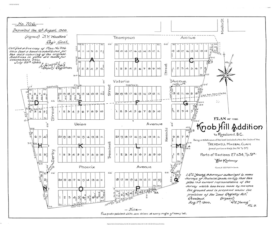
On Aug. 7, 1900, R.E. Young laid out the Knob Hill Addition on the Treadwell mining claim south of the Durham Addition and deposited the plan with the land registry nine days later. It further extended Thompson and Victoria avenues to the west and added Union and Phoenix avenues on the south. However, today only portions of the latter two streets exist, to the east of the addition.
Knob Hill’s north-south streets were Derby, Treadwell, and an extension of Nevada. Derby doesn’t exist today, while only a small portion of Treadwell survives, connecting to Black Bear Drive.
At least three other additions were laid out by 1900: White Bear, on the mining claim of the same name, was northwest of the Durham Addition; Dunn Crescent runs through part of it, but none of its original streets exist, whatever they were called.
Meanwhile, Rossland West wrapped around the White Bear, Durham, and Knob Hill additions to the south. Its new north-south streets were California, San Francisco, and Mayflower. It also would have extended MacNeill, Durham, and Dunn streets from the Durham Addition further south, and extended Phoenix Avenue from the Knob Hill Addition further west.
Four other east-west avenues appear at the south end of Rossland West on a 1900 map: Princess, Kitchener, Beresford, and Sunset, the latter two of which only stretched for three blocks between Treadwell and Cliff.
Virtually none of Rossland West came to be, although portions of Princess and Phoenix avenues survive in three non-contiguous sections well to the east of the addition. There’s also a small remaining part of Kitchener Avenue.
The Nickel Plate Addition was laid out on the mining claim of the same name and included extensions of Second through Fifth avenues between Cliff and Spokane.
But there was a problem with all these additions: some streets didn’t line up. More on that next week.
— With thanks to Ron Shearer and Jackie Drysdale