Two hundred fifty-third in a series on West Kootenay/Boundary place names
In 1908, the Winnipeg real estate firm of Fisher-Hamilton Co. proposed a new fruit growing subdivision at the north end of Slocan Lake, near present-day Hills. They called it Cherrydale.
Most of what we know about the scheme appeared in the Slocan Mining Review on May 7, 1908, when W.S. Fisher, a principal in the company, came to inspect the property of several hundred acres.
The land had a complicated history: John M. Cameron, Denis St. Denis, and Angus McInnes purchased it from the Crown, then sold it to Toye & Co. of Nelson, who transferred their holdings to a syndicate of businessmen headed by Victor Odlum. Odlum and his colleagues in turn teamed up with Fisher-Hamilton to survey and subdivide the land.
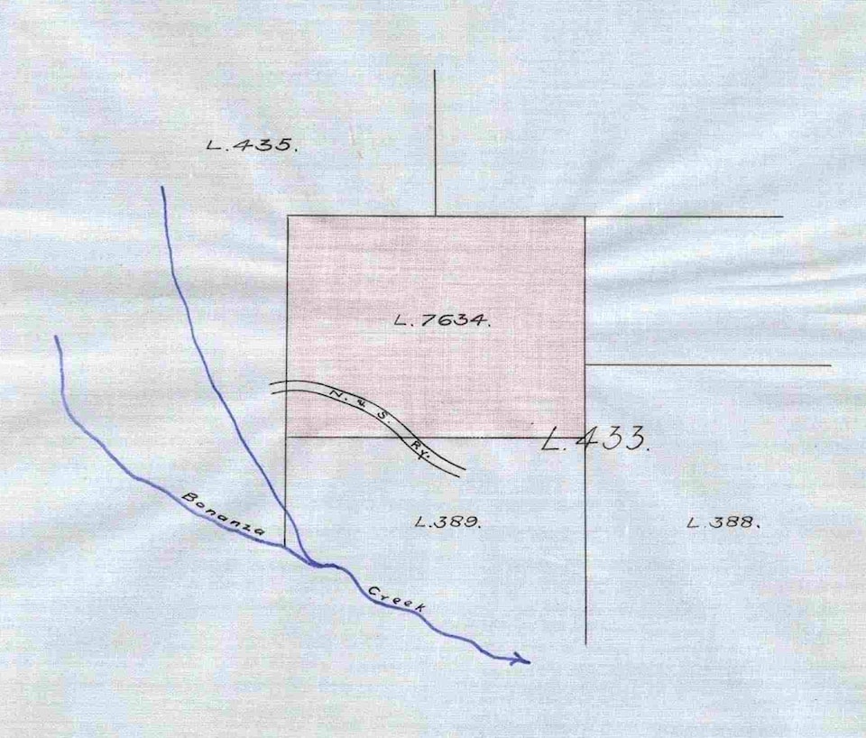
It’s unclear exactly which holdings made up Cherrydale, but we know Cameron received a 117-acre Crown grant for Lot 7634 on June 25, 1907, through which the Nakusp and Slocan Railway passed. Bonanza Creek flowed through Lot 389, directly to the south.
On May 20, 1907, St. Denis received a 100-acre Crown grant for the L-shaped Lot 7547, which was a bit north of Cameron’s lot; they were separated by Lot 435, whose ownership is unclear.
On Nov. 28, 1907, McInnes received a 200-acre Crown grant for Lot 8506, also adjacent to Lot 435. The railway ran through its southwest corner.
Fisher proudly displayed his prejudices, declaring in an interview that his company would not sell to “Doukhobors or other undesirable foreign settlers” and “felt sure that all would be proud of the British settlers his firm will send among us.”
In any case, Cherrydale was a bust. It was never mentioned again.
HILLS, REVISITED
Previously the earliest known newspaper reference to Hill’s Siding (now just known as Hills) was from 1907. But an earlier one has appeared, in a list of mining claims printed in the New Denver Ledge of July 14, 1904: “June 28 – Spitze, near Hill’s Siding, John Brenan.”
Hill’s Siding was named after Alfred (1850-1907) and Wilson (1862-1929) Hill, who had a sawmill there from about 1893 to 1903. It was added to the CPR timetable on Oct. 14, 1900, but took a while to join the local lexicon.
BROUSE, REVISITED
Our installment on Brouse, south of Nakusp, stated that the first mention of the community was the opening of the post office on Jan. 1, 1910.
A slightly earlier reference has since been found: on Nov. 18, 1909, Engelbert Pieters married Sophia Maria Hoogemoerf. Their marriage registration listed both as residing at Brouse, while the wedding was said to have occurred at the Brouse church. Six days later, the Revelstoke Mail Herald carried an announcement about the wedding, which also stated that it occurred at Brouse church but gave the residence of bride and groom as Nakusp.
Brouse was named after Dr. Jacob Edwin Brouse (1868-1925), an early New Denver physician. His father and his son were also doctors, and all graduates of McGill University.
PRINTER CREEK
This unusually-named stream flows south into Enterprise Creek in the Slocan Valley. It was first mentioned in the New Denver Ledge on Aug. 29, 1895 in a list of mining claims. J.J. Langstaff located the Alexander “on Printers creek, Aug. 23.”
The name also appeared on William Thomlinson’s 1896 map of Slocan Lake and District. A travelogue by journalist Weston Coyney in the Slocan Pioneer of Jun 26, 1897 explained its origin:
“One of the brightest conversationalists and best informed men I met on my trip was C.E. Smitheringale, who whiled away my evening at the Enterprise mine. He is a journalist well known in this part of the Kootenays and with another journalist named Langstaff helped to immortalize the craft by naming one of the tributaries of Ten Mile [Creek] Printers’ Creek. On this creek he and R.M. Covington, T. Reed, G.B. Scott, and H.H. Knox have located the Slug Ten mineral claim, another printer’s term.”
Charles Edward Smitheringale (1869-1950) worked on the Ledge at the time and later became proprietor of the Slocan Drill. John James Langstaff (1873-1942) was editor of the Sandon Paystreak and later launched the Trout Lake Topic.
The name was officially adopted as Printer Creek in 1924.
LAWN AND EXTREME WEST
Certain place names mentioned in old newspapers are utterly baffling to modern eyes. The papers evidently assumed their readers were familiar with the spots they were talking about, but they mean nothing today.
One such example, from the Nelson Daily News, Sept. 9, 1912: “Ainsworth needs trails that would make it much more convenient between Lawn and Woodbury.”
There were lots of obscure sternwheeler landings on Kootenay Lake, but where the heck was Lawn? And who or what did the name refer to?
Another example in the Nelson Daily News, Dec. 11, 1911: “Rev. A.P. Durrant of Edgewood will hold church services at Yarrow ranch, Westley, every fortnight for the settlers at Extreme West, Westley, and Syringa Creek.”
Extreme West? Presumably it was further west than Westley (whose name was, apparently, a “remote corruption” of nearby West Robson), but it was never mentioned again.