Sign In
Subscribe Now
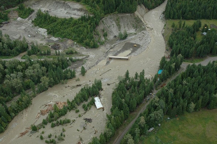
The above photos taken during a flyover today by the Ministry of Forests show the extent of this week's flood damage in several locations around Kootenay Lake.
The photos show Hamill Creek, Crawford Creek, Schroeder Creek, and Campbell Creek.
In a news release today, the Regional District of Central Kootenay also said some erosion has occurred along a temporary berm on Crawford Creek, on the East Shore.
RDCK staff member Robin Douville and provincial hydrologist Alan Davidson assessed the site Thursday afternoon and found water seeping through the rock and gravel berm, but it remains relatively sound.
Of greater concern, they say, is a log jam about 500 meters up the berm affecting its earthen portion. Heavy rain could cause an overflow, although the dropping creek level should reduce the likelihood.
A major failure isn't expected barring heavier-than-forecast rain. The forecast calls for up to 20 millimeters over the next few days. Most water systems, including Crawford Creek, have peaked and are dropping slowly.
Residents are urged to stay well clear of creek banks due to the danger of saturation and undercutting. To report an incident, call 1-800-663-3456.
More floodwatch stories and pictures:
Kaslo-New Denver washout in photos
Highway north of Kaslo reopens
Schroeder Creek Resort evacuated
Trailer washed away in Hamill Creek
About the Author: Staff Writer
Dialogue and debate are integral to a free society and we welcome and encourage you to share your views on the issues of the day. We ask that you be respectful of others and their points of view, refrain from personal attacks and stay on topic. To learn about our commenting policies and how our community-based moderation works, please read our Community Guidelines.