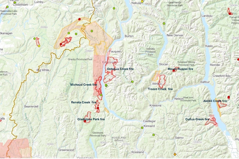
BC Wildfire Service (BCWS) is planning a controlled burn at the Trozzo Creek wildfire near Winlaw to remove fuel from the fire’s path in an area of steep and unstable terrain, according to a July 26 bulletin.
The planned ignition will target an area of approximately 50 hectares near the five-kilometre mark on the Trozzo Forest Service Road, the bulletin states. Increased smoke from this action may be visible in the area between Winlaw and Slocan.
The timing of this burn will depend on weather and site conditions, but it could begin as early as July 27.
“Highly trained BCWS personnel will use hand torches to carry out the planned ignition on the site, which is contained by a machine guard, a retardant line and the Trozzo Forest Service Road,” the bulletin states. “Hose lay systems and helicopters with bucketing capacity will support the safe execution of this planned ignition.”
The bulletin emphasizes that there are strict safety precautions in place.
“Large-scale burn operations are supported with appropriate resources, such as aircraft, heavy equipment and firefighters. This way, if a burn escapes, it can be dealt with right away. Given the aggressive behaviour that we’ve seen on many wildfires, there is a potential for escaped fires, but that potential would also exist if the BCWS did not conduct these planned ignitions.”
Residents meet with BCWS
On July 24 at the Winlaw Hall, BCWS representative Ryan Gow met with residents to discuss the Trozzo Creek wildfire.
“He was reassuring,” said resident Joel Pelletier, who lives on Fern Road near where the fire started. “He was good at explaining exactly what was happening.”
Using a large map, Gow showed what the firefighters were doing in each zone of the fire, which, as of July 26, has grown to 4,389 hectares and caused the evacuation of 16 households. Many others, including Pelletier, are on evacuation alert.
“The truck is loaded, motorbikes on the trailer ready to go, sprinklers on the roof,” he said.
Pelletier said he was glad to hear that firefighters are creating a second break below the Trozzo Basin, so if the fire does break through there will be a second break.
If the fire broke through, he said, it would be closer to the highway and make all the houses on the highway vulnerable.
In an email to the Nelson Star, Gow wrote, “I tried to put myself in their shoes and give them the most accurate information that was most relevant to them.”
There are currently 90 firefighters, five helicopters and 20 pieces of heavy equipment on the fire, according to the BCWS.
Cold drinks for the fire fighters
Pelletier said residents have been putting coolers of cold drinks at the foot of the two forest roads from which the fire fighters access the fire.
“I’ve witnessed the firefighters getting to the bottom of the hill at the end of the day, getting out of the car as fast as they can, opening up that cooler, grabbing a Gatorade or bubbly water and just downing it, and just super enjoying that drink. I mean, it’s just a couple of coolers on a logging road, but it’s great support for the firefighters.”
He said the BCWS presenter at the community meeting said this is the first community that has ever done this for firefighters, who greatly appreciate it.
“So that really hit home for us because this valley is so special as far as community support goes,” Pelletier said.
Floaters interfering with helicopters
Pelletier has a message to people floating on the Slocan River in the vicinity of the fire: please don’t. You could be in the way of helicopters filling their buckets.
“Our swimming hole is at Perry’s bridge, which is a nice swimming hole, and that’s where a lot of the floaters start their floats down the valley. It is really is frustrating to me, to witness helicopter pilots having to dodge those floaters.”

bill.metcalfe@nelsonstar.com
Like us on Facebook and follow us on Twitter