Two hundred nineteenth in a series on West Kootenay Boundary place names
We’ve spent the last two instalments looking at how Creston became Sirdar and then Creston again. A few follow-ups: Fred G. Little’s obituary in the Creston Review of Oct. 3, 1924, adds some more details: “The naming of the town Creston is entirely due to Mr. Little’s insisting on the name when part of the townsite was acquired by the CPR. First of all the place was called Kitchener [sic], then Fisher, and lastly Creston — after Creston, Iowa, which is the first divisional point on the Chicago, Burlington & Quincy Railway east of Council Bluffs, on which line he got some early experience as brakeman.”
Little was born in Plymouth, England but immigrated to Canada with his parents in 1857. His father was a divisional official on the Grand Trunk Railway at Thorold, Ont., where Little grew up. His obit says he left “at a quite early age” to work in the US as a railway brakeman and conductor before returning to Canada in 1880. Creston, Iowa was founded in 1868, so that leaves a 12-year window where he could have worked there.
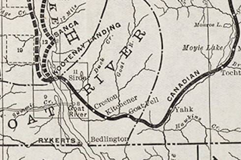
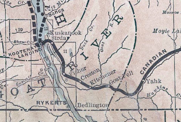
Meanwhile, Howard Boyle has located three different versions of the same CPR map, which adds to the intrigue over whether Creston was the seventh, eighth, or some other-numbered siding when counting from Cranbrook.
The first map is dated 1897 (although looks to actually be from a year or so later) and shows Creston as the seventh siding, between Kitchener and Sirdar. The second map, from July 1901, shows it as the eighth siding after a new siding called Aldridge was added between Moyie and Tochty. But what’s really odd is that Fisher appears as the ninth siding, even though by now Fisher was supposedly renamed Creston. The third map, from January 1904 shows the same thing.
GOAT RIVER CROSSING
Boyle also points out that before Creston appeared in the civic directory and on railway timetables, the closest community was known as Goat River, or Goat River Crossing (not to be confused with Goat River Landing, an early name for Kuskonook). Presumably the name reflected the fact the Dewdney Trail crossed the river at this point, slightly northwest of present-day Creston.
Goat River first shows up in the 1897 directory as “a station and mining camp” without a precise location and the following year is described as “17 miles from the head of Kootenay Lake.”
Three hotels popped up in anticipation of railway construction, operated by J.S. Ingram, Harold Pollard, and A.D. McLennan (who apparently also had a hotel in Trail). Goat River was still listed in 1899-1900 and 1900-01 but was down to two hotels (McLennan’s had apparently closed). It was gone entirely in 1901.
Three newspaper notes exist on these hotels from 1898. The Fort Steele Prospector of March 12 carried Pollard’s application to sell liquor “on the premises known as the Summit Hotel situated at the summit of Goat river.”
The Cranbrook Herald of Sept. 29 related this anecdote but didn’t name the hotel or proprietor: “A man near the Goat River crossing had an hotel constructed of logs with an immense room for a bar. One day recently, when the railroad gang reached the place, he did over $400 of business at the bar. The next day he was called upon for his license, and it is stated that he failed to produce the necessary documents and his liquors were confiscated. It is told that two barrels of whiskey, 15 cases of beer and one dozen cases of bottled goods were emptied on the rocks amid the sorrowful lamentations of the crowd.”
And finally, on Nov. 12, the Cascade Record reported: “J.S. Ingram & Co. are erecting a store building on First avenue [in Cascade] … They were formerly of Goat River Crossing.”
HYDE PARK
This may have been a failed rival to Creston. On March 17, 1897, John Arrowsmith (1857-1935) obtained a Crown grant for Lot 526, directly south of Fred Little’s ranch on Lot 525 that became Creston. Here Arrowsmith apparently built an hotel as part of a grand vision.
According to the Nelson Tribune of Feb. 3, 1899: “Hyde Park … is to be a point on the Great Northern railway. It may be the junction of the two roads, but the company has not agreed to maintain an agent at this point … Mr. [George] Bigelow is dubious of the future of Hyde Park. He thinks that to make a townsite out of Hyde Park it will be necessary to cut down some of the trees during the cold weather and make the same into firewood, so that should an inhabitant come along he could pack the wood into his residence. As yet nothing of this kind has been attempted, and failing it the people of the neighbourhood may view with suspicion the efforts of Mr. Arrowsmith to make a town out of a townsite … [T]he people of Creston naturally look down upon Hyde Park and refer to it as a mushroom town of questionable future.”
It was only ever mentioned once more, in the Nelson Daily Miner of Sept. 8, 1899: “Mr. John Arrowsmith, the popular proprietor of the Hyde Park Hotel near Creston, is putting his place in shape for the winter trade.”
(Hyde Park is a major park in central London, although Arrowsmith hailed from Utah, not England.)
In the 1899-1900 civic directory, Arrowsmith was listed as a Creston rancher. He was prominent in the valley for the rest of his life. While Hyde Park went nowhere, Arrow Creek — the body of water and community, often spelled Arrowcreek — may have been named after him. The Arrow Creek post office operated between 1936 and 1950.