One-hundred eighty-sixth in an alphabetical series on West Kootenay/Boundary place names
Sproat’s Landing was an early transportation hub on the north side of the Columbia River, near the mouth of Pass Creek — roughly where the Castlegar sewage lagoons and CPR bridge are today.
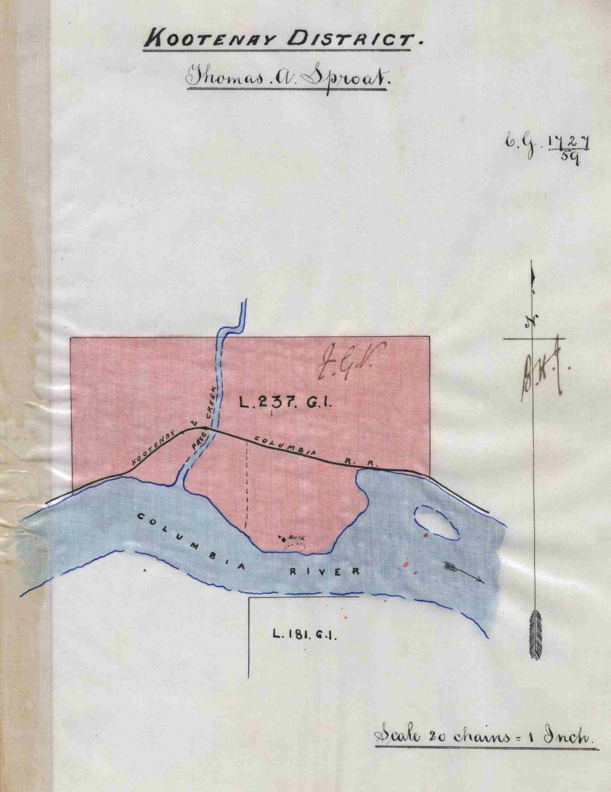
It was first mentioned in a legal ad placed by lands commissioner F.G. Vernon on Jan. 26, 1888 and published in the Victoria Daily Colonist two days later: “Notice is hereby given that the following described blocks of land have been reserved from sale or settlement until further notice: A square block of 40 acres fronting the east [sic] side of the Columbia River, on the flat about two miles north of the mouth of Kootenay River, known as ‘Sproat’s Landing.’”
It was named after Thomas Alexander Sproat (1831-1911), who pre-empted 320 acres on Lot 237 on May 28, 1888 and had a farm there. He also served as postmaster from 1890 to 1891.
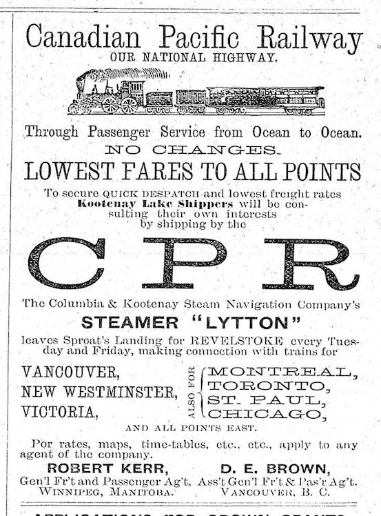
Sproat’s became a key stopping point for sternwheelers on the Columbia and traffic heading up the Kootenay River. For a short time, it was also the western terminus of the Columbia and Kootenay Railway to Nelson. However, when the line was extended to Robson in 1891, Sproat’s Landing was dealt a near fatal blow.
Thomas Sproat was an elder brother to Gilbert Malcolm Sproat (1834-1913), a prominent figure in BC generally and West Kootenay officialdom especially, who is sometimes mistakenly attributed as Sproat’s Landing namesake. It didn’t help that Gilbert made a baffling statement on the subject, quoted by T.A. Rickard in the BC Historical Quarterly in 1937:
“I have never been able to discover what or where Sproat’s Landing was … All that I know about the matter is that according to my diary, on the 23rd of October 1888, I saw from my canoe a towel attached to a pole on the Columbia River bank somewhere about the mouth of the Kootenay River … On landing I found also on the pole a yeast powder can containing a letter addressed to me from Kootenay Lake. The incident and perhaps my prank with the towel amused the Indian crew and they, I suppose, spoke and continue to speak of the place ‘where Mr. Sproat landed.’”
This was nonsense.
In Trails in Time: Reflections, Walter Volovsek says he and the late historian Ted Affleck “concluded independently that there was something very fishy in regard to Gilbert Sproat’s purported ignorance about the naming of Sproat’s Landing. In his memoirs, he purposely ignored the obvious presence in the area of his brother Thomas … to obscure the reason for his less than honorable departure from the Kootenay stage.”
Gilbert was fired from his government appointments for dabbling too brazenly in real estate.
“It appears that Thomas acted as a front for his more famous brother Gilbert and his accomplice Arthur Farwell,” Volovsek adds. “Both were government agents who could stand to profit by applying their specialized knowledge to speculate in real estate.”
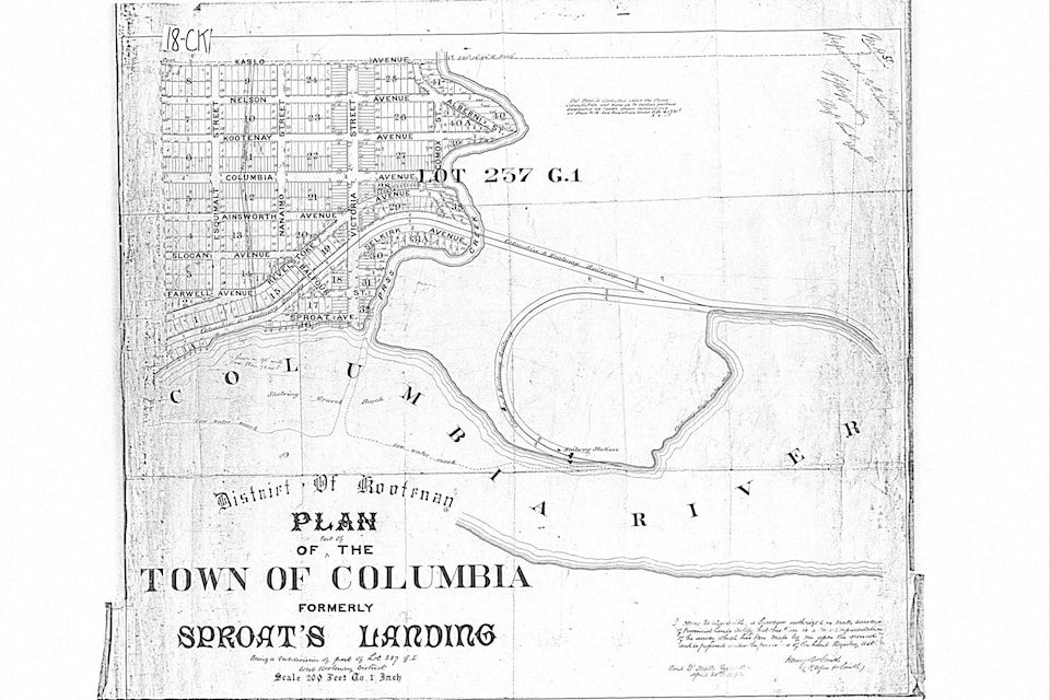
Thomas obtained a Crown grant for the nearly-deserted site of Sproat’s Landing in 1892, and promptly sold it to a Victoria syndicate for $8,000. They in turn laid out a new town called Columbia. While Sproat’s was mostly or entirely east of Pass Creek, Columbia was entirely on the west. It was first mentioned in the Daily Colonist of March 29, 1892: “The new town of Columbia, formerly known as Sproat’s Landing … will be subdivided at an early date. Mr. H.B. Smith, C.E. (Keefer &Smith) … will carry out the work.”
Smith’s townsite plan survives and shows streets named Esquimalt, Nanaimo, Victoria, Comox, and Alberni, and avenues named Kaslo, Nelson, Kootenay, Columbia, Ainsworth, Slocan, Farwell, and Sproat. However, nothing became of Columbia, and the name reverted to Sproat’s.
The flood of 1894 might have washed Sproat’s Landing off the map for good, but it came back to life the following year when a railway spur was built to allow steamships to avoid Tin Cup Rapids. The line was abandoned in 1897.
In the 1910s a farming settlement called Sproat emerged on the east side of Upper Arrow Lake, five and a half miles north of Arrowhead and a quarter mile from Sidmouth, which eventually subsumed it. A post office operated from 1916 to 1919 whose records have been erroneously merged with Sproat’s Landing. The second Sproat was presumably named after Mount Sproat, which towered over Arrowhead, and was in turn named after Gilbert by 1889. Gilbert is also remembered in Sproat Lake, west of Port Alberni, which was renamed in his honour in 1864 (it had been Kleecoot Lake) plus Sproat River and Sproat Narrows in the same area, and Sproat Bay in Barkley Sound.
Gilbert is further credited with naming Nelson after Lt.-Gov. Hugh Nelson in 1888. (He thought either Stanley or Nelson would do, but Stanley was already taken by a town in the Cariboo.)
As for the pronunciation of Sproat, Gilbert set the record straight in a 1908 letter to the provincial archivist: “I say nothing against Brussels sprouts, which I love to eat, but tell your typist that I was christened with an ‘a’ and not a ‘u.’”