David Thompson is recognized as an explorer who connected closely with the natives he met, and a maker of remarkably accurate maps. He surveyed the rivers he travelled on by using astronomical observations as well as course bearings and distance estimates. The geography of landscapes at some distance from his travel route was filled in from information obtained from his native friends, or else by conjecture.
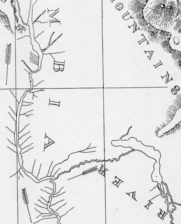
His final map of the local area shows that approach very well, and poses an interesting question. He explored it somewhat tentatively during his stay in the vicinity of the Columbia-Kootenay confluence on Sept. 5, 1811. His journal talks about a journey a small distance up the Kootenay River, possibly a bit beyond the rapids at the spot now occupied by Brilliant Dam.
He had explored to southern part of Kootenay Lake the year before, and knew its outlet pointed the flow south-westward to join the Columbia, where he now found himself. The natives also told him that stretch of the river was difficult to navigate as it required many portages. The Sinixt had developed an alternate overland route via Pass Creek, which rejoined the Kootenay upstream of the major impediments. He refers to that route in his journal entry the following day.
The resulting map is very interesting. It shows the Kootenay River fairly accurately, with the notation “7 to 11 carrying places, depending on height of water.” Pass Creek is drawn in incorrectly, extending itself well to the east toward the upper end of Kootenay Lake, which has been curved westward to approach it. What is startling about his map is that Slocan Lake and river are missing. They were part of the native travel routes.
The London map-maker, Arrowsmith, depended on information obtained by fur company traders and explorers, and he shows Thompson’s concept in the 1818 edition. The remarkable thing is that the publisher removed Slocan Lake and river, which are clearly shown in the 1814 edition of his map of western North America.
If we compare the revised 1818 Arrowsmith map with Thompson’s 1816 map, the explorer’s influence is obvious. Kootenay Lake (which Thompson called McGillivray’s Lake, and Arrowsmith, Flat Bow Lake) is no longer vertically oriented, but is curved strongly westward. Slocan Lake and river have disappeared, to be replaced by a chain of mountains. And Pass Creek is clearly indicated, although the cartographer did not have Thompson’s confidence in having it punch through the mountains into such proximity to Kootenay Lake.
When I approached Barbara Belyea, editor of Thompson’s Columbia Journals, with this perplexing mystery, she suggested Arrowsmith’s earlier information might have come from James Howse, working with the competing Hudson’s Bay Company. Although he never explored the Columbia River, as did Thompson for the North West Company, Howse had a better understanding of the Lower Kootenay. He probably obtained that information from the Kootenay (Ktunaxa) natives, which he met near the continental divide.
That raises a fascinating question. Why was Thompson not told of the nearby Slocan valley by his Sinixt friends, who accompanied him on his first journey along this stretch of the Columbia? The answer in my mind is simple. The Sinixt valued the Slocan valley, with its prize salmon fishery and ancestral burial grounds, much too highly to give that secret away to the white man, who was claiming everything. It has the appearance of a last desperate measure to protect a very special place.
The Ktunaxa, of course, had no such reservations. They had fought and lost a bloody battle over the Slocan valley with the Sinixt. Without that, or direct access to the Columbia at the confluence, they were restricted to harvesting only the poorer salmon that had managed to fight their way over the upper Columbia rapids to make it into Ktunaxa territory.
If anything, the Sinixt could control even that with the fishing weir they had across the Columbia just upstream of the confluence. This would have given them the ability to control the passage of fish further upstream and to divert more of them up the Kootenay and the Slocan, where fishing was easy. Another fishing weir existed at the mouth of the Slocan River for the purpose of harvesting fish and regulating their passage further upstream.
Visiting fishing rights at the confluence were granted to the Ktunaxa after the closure of the fur trading period. The relationship between those First Nations prior to that, however, has all the appearance of tribal politics and a contest over very valuable ground.
Walter Volovsek’s website can be found at trailsintime.org
Previous installments in this series
Reappraising the Franklin Expedition
Connecting with Albert McCleary
Lilette Mahon: A mentor’s gift
Edward Mahon: Searching for a legacy
Edward Mahon: A stimulating childhood
Intrigues: Castlegar’s lacklustre childhood
Perceptions: Adrift on the River of Life
Local history interwoven with rivers
Drawn into the currents of time